The Story of Polk County’s Roads: How History Shapes Today’s Safety Challenges
If you’ve ever driven a Polk County road that curves for no obvious reason, dead-ends near a lake or narrows without warning, there’s probably a story behind it. Most of our roads didn’t start on an engineer’s drawing board. They started as Native American footpaths, military supply routes and old grove roads. Over time, pavement went down on top of those earlier paths, and the roads we drive today still carry the shape of decisions made long before anyone imagined modern traffic.
Understanding that history plays an important role in the Polk Transportation Planning Organization (TPO) Vision Zero Polk initiative, which focuses on eliminating traffic deaths and serious injuries. Knowing how a road was developed helps identify where targeted safety improvements can be most effective.
How Polk County’s Roads Formed
Before Polk County, Florida existed on any map, the Calusa, Tocobaga and Timucua created footpaths along Central Florida’s ridges, around its lakes and through its hammocks. When U.S. troops arrived in the 1830s, they widened those trails into military roads to move soldiers and supplies between outposts like Fort Brooke, Fort Meade and Fort Fraser. Colonel Zachary Taylor’s trail is one of the best-known examples.
Those early military roads established the first lasting travel patterns in the area, and settlers kept using them long after the soldiers left. During World War II, military roads again played a role, connecting the Bartow Army Airfield and Drane Field Army Airfield outside Lakeland to Tampa.
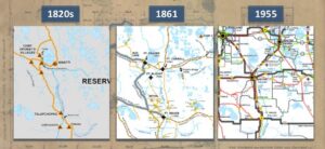
Polk County’s transportation network evolving from Native American trails to modern roads, 1820s–1955
Grove Roads and Organic Growth
When citrus agriculture took off in the late 1800s and early 1900s, growers carved out roads to reach their fields, packinghouses and rail lines. These roads curved around lakes, skirted wetlands and followed property boundaries. They worked fine for wagons and trucks, but nobody was thinking about the speeds and traffic volumes we see today.
Historic maps from the 1910s and 1920s show that when the county started paving roads, crews usually paved whatever was already there rather than redesigning the route. The result is a network that grew organically, shaped more by the land and its landowners than by engineering principles.
“Imperial Polk County” and the Rise of a Regional Hub
As the county became a center of agriculture, rail and commerce, locals liked to joke that all roads lead to Rome, but in Florida they lead to Polk County. The nickname “Imperial Polk County” captured how roads from every direction seemed to converge here. That wasn’t the result of a master plan. It happened because early trails and grove roads already pointed toward the region’s economic heart.
Air Conditioning Changes Everything
The widespread adoption of air conditioning in the mid-20th century changed Florida forever. Comfortable indoor living made year-round residency possible for millions of people, and Polk County’s affordable land, sunshine and job opportunities drew waves of new residents. Traffic surged on roads originally built for grove trucks and local travel, not suburban commuters and regional through-traffic.
Not every road in the county fits the organic-growth story. As cities like Lakeland and Winter Haven expanded, they began using formal surveying and newer subdivisions added more organized street grids. Over time, larger roads and state highways were added on top of the older network. The result is a hybrid system, part planned and part inherited.
That mismatch between historic road design and modern traffic demand is one of the root causes of today’s safety challenges.
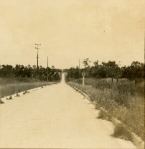
Road to Alturas with Lake Flora in the distance, May 1919. Polk County History Center Collection.
Why This History Matters for Vision Zero Polk
Vision Zero Polk is built on the idea that roads should be designed to forgive human mistakes, not punish them. Polk County’s history helps explain why certain corridors keep showing up in crash data.
Roads that curve around lakes can encourage drivers to travel faster than the geometry safely allows. Former grove roads often lack shoulders, lighting or clear sight lines. Irregular intersections created by old property lines produce conflict points that modern engineering would avoid. And legacy corridors originally built for wagons and grove trucks now carry regional traffic at speeds no one anticipated.
Understanding these origins helps us see that today’s safety problems aren’t about blame. They’re about design.
Re-Engineering Can Save Lives
Targeted redesigns of road sections where crashes regularly occur can reduce deaths and serious injuries. Re-engineering doesn’t erase heritage. It adapts inherited corridors to protect the people who use them now. In a county shaped by lakes, ridges and groves, that might include straightening or softening dangerous curves, redesigning irregular intersections into roundabouts or other predictable forms, adding shoulders and lighting and protected pedestrian crossings, or creating parallel routes where historic alignments simply can’t carry modern traffic safely.
What Does This Mean for Polk County’s Future?
Polk County’s roads weren’t drawn on a grid. They grew from trails, groves and early settlements. That organic history explains why some roads feel unpredictable and why certain corridors see more severe crashes. As Florida’s population surged, especially after air conditioning made year-round living possible, traffic increased on roads never designed for it.
By understanding how our road system came to be, we can support smart, targeted re-engineering that preserves Polk County’s character while making our roads safer for everyone.
How the Polk TPO Is Helping Build a Safer Network
This is where the Polk TPO comes in. The TPO works with local governments, state agencies and community members to study how people move through the county and to plan transportation investments that make the network safer, more connected and more reliable. That work includes analyzing crash data to identify high-risk corridors, coordinating long-range plans that account for population growth and prioritizing projects that address the root causes of serious crashes.
Through Vision Zero Polk, the TPO is applying these studies to find real solutions. By understanding the roads we have, understanding why they were built the way they were and planning improvements based on data, the Polk TPO can help turn history into a future roadmap for saving lives.