Central Polk Parkway East Alternative Corridor Evaluation (ACE)
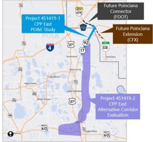

Florida’s Turnpike Enterprise (FTE) is conducting an Alternative Corridor Evaluation (ACE) for a new north-south facility in eastern Polk County. The ACE, a planning-level study, aims to identify a potential corridor location for a new tolled, limited-access highway connecting State Road 60 and U.S. Highway 17/92. The proposed highway will provide a direct link to I-4 and State Road 429 (Western Beltway) through the future Poinciana Connector (SR 538).
The proposed highway is expected to serve as a high-speed, alternate travel route to U.S. Highway 27, which currently experiences heavy traffic congestion. This congestion is anticipated to worsen due to population growth and increased travel demand. The proposed highway, currently referred to as the Central Polk Parkway East, will extend nearly 28 miles. The corridor study area is shown on the map highlighted in purple.
Stay tuned for further updates as the project progresses and more details become available.